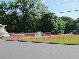
I've heard from many of you regarding the closure of the trailhead on Pumphrey Drive near the Main Gate of NAS Fort Worth JRB (Naval Air Station Fort Worth, formerly Carswell).
In short, the trailhead is being improved and will not reopen until late Fall of 2012.
Here's the rest of the story... When it reopens, this trailhead will be called "Airfield Falls Trailhead" after the waterfall (Airfield Falls) that can be found just a short distance down the trail from the trailhead. According to Rachel Navejar at the TRWD:
"We have closed the area soon to be called Airfield Falls Trailhead until construction of the trailhead is complete. This also assists us with security of the recently acquired airplane wings and tail section which will be incorporated into the trailhead depicting the rich history of the NASJRB, Lockheed and the bomber plant in Fort Worth. With our current schedule we hope to open the Airfield Falls Trailhead by late fall."
According to a Facebook page for the Airfield Falls Trailhead that was set up by Trinity River Vision, the Navy C-9 tail section that is currently on site will be used as a shade structure for the new trailhead. Currently the wings have also been delivered to the site.
Navejar also mentioned that there is a sign indicating other ways to access Airfield Falls, but as you can see in the photos below, it is difficult to get close enough to this sign to read it as the new fence runs right alongside Pumphrey Drive. One recommendation on the sign is to access the trail from the trailhead at White Settlement and Isbell Rd., but this is a 3 miles from the Falls. A closer access point is where the trail crosses under 183/River Oaks Blvd.
The airplane parts currently stored at the site are fenced seperately from the fence that is blocking access to the trailhead, so I wonder why it is necessary, at least at this point, to prevent access to the trail. This is especially curious since one can access the trailhead area, all the way up to the other side of the fence along Pumphrey drive, from the trail itself.
 |
| Navy C-9 tail fin and fence across entrance to the trailhead. |
 |
| Closed trailhead; showing tailfin and sign with information on other trailheads to access the water fall. |
 |
| Artist rendering of the 'shade structure' for the trailhead. |
 |
| Trail "Detour" sign. Unfortunately, it can't really be seen (not safely anyway) when the trail is closed. :( |
 |
| Airfield Falls from the Trinity Trails. |
No comments:
Post a Comment